New Orleans topography and flooding
An article in The Times-Picayune today is confirming what New Orleanians already know intuitively, and which has been explained elsewhere in PGR:
Our great-great-grandparents knew what they were up against.
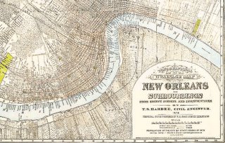
An 1878 map of New Orleans' settled areas shows that most of the city's 200,000 residents at the time clustered in a narrow swath along the Mississippi River, settling on the natural levees created by periodic floods.
It was still a good idea 127 years later. The city's old footprint corresponds closely to the small area that remained dry in the disastrous floods that came after Hurricane Katrina.
Indeed, the storm served up an unwelcome reminder that the city's expansive interior, pumped dry in the first few decades of the 20th century, is mostly reclaimed swampland. The killer storm essentially recreated what was here when Bienville founded the city in 1718.
For readers who can't pick up a copy of the Times-Picayune, a PDF snapshot of the article shows the maps discussed in the article (I recommend saving the PDF file to your hard drive before trying to view it).
What the Times-Picayune article fails to note is that areas along the Mississippi River did flood almost every spring until the levees were raised following the disastrous 1927 flood - or so I have been told. That's why residents built raised homes. When floods occurred, people would canoe to work, and wealthier families would leave for vacations until the flooding subsided. What was a good architectural practice then remains a good practice today.
Compare this New Orleans flood map to this elevation map for another visualization of the correlation between elevation and flooding. The areas where there was little to no flooding (French Quarter, Marigny and Bywater, Garden District, Uptown), are the older areas of the city.
The best study of New Orleans topography that I know of is Richard Campanella's Time and Place in New Orleans: Past Geographies in the Present Day.
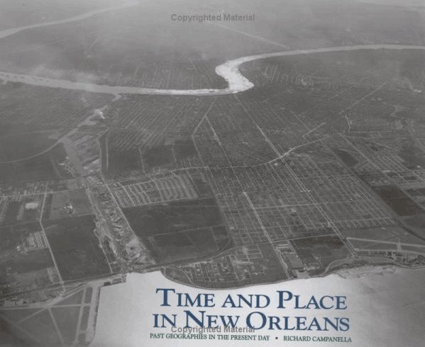
The book is packed full of interesting maps and aerial photographs. Campenella is a researcher at the Tulane/Xavier Center for Bioenvironmental Research (the CBR Web site is currently unavailable).
For more on the topography of the Mississippi Delta and flooding, John Barry, author of Rising Tide: The Great Mississippi Flood of 1927 and How It Changed America, has been interviewed on NPR at least a couple of times.
Finally, a reading of Mike Tidwell's Bayou Farewell: The Rich Life and Tragic Death of Louisiana's Cajun Coast, which examined the Louisiana coastal erosion can be heard on the Web site of Monroe, Louisiana's KEDM.
posted by Schroeder @ 8:17 AM
1 comments
![]()


1 Comments:
This comment has been removed by a blog administrator.
Post a Comment
<< Home