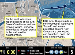
Map: Levee breach timeline
If there were a Pulitzer for Geographic Information Systems graphics, Dan Swenson should have won it. His work providing a spatial overview of when and where things have happened around New Orleans has done as much to help people understand what happened during the storm, and since the storm, as any writer on The Times-Picayune staff. Can anyone really imagine getting a grasp of what's happened without maps?
Now comes this OUTSTANDING movie by Dan Swenson and T-P outdoors correspondent Bob Marshall of events on August 29:
This is the accompanying Times-Picayune article.
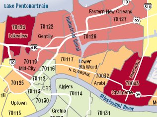
5/15/06 update: The New York Times has a lousy example of how not to use GIS in this flood insurance map -- attempting to illustrate (I think) that a lot of New Orleanians should have bought flood insurance.
Aside from the fact that the mix-matched shading makes the map nearly incomprehensible, what's particularly wrong with the NY Times map is that it aggregates data in ways that overemphasize cases where people weren't required to have flood insurance.
The map aggregates homeowners and renters together. There are probably a miniscule number of renters who can afford, let alone who consider, flood insurance. Most homeowners are compelled to consider their flood possibilities and to buy flood insurance because their lender requires it. The map further aggregates data by zip codes, when clearly, most of the zip code boundaries straddle both FEMA-designated flood and non-flood zones.
In actual fact, The Times-Picayune revealed that 67 percent of single-family homes in New Orleans had flood insurance before Hurricane Katrina -- one of the highest percentages of homes insured against flooding in the country.
In March, Dan Swenson also created a much more comprensible map of expected flood insurance payments by zip code.
Going back to February, another T-P graphic artist, Emmett Mayer III created a set of charts for affected parishes which showed the numbers of homes inside and outside of designated flood zones that had flood insurance.
Tags: New Orleans | Hurricane Katrina | Louisiana | Levee | Flooding | Katrina Geographic Information Systems | Katrina GIS | Katrina map |


2 Comments:
You're right. This is absolutely essential reading. I learned more from that brief slideshow than I did from dozens of news articles.
Count the number of times Dan Swenson and Emmett Mayer III get placement above the fold to realize how important what they do is.
Post a Comment
<< Home