Maps: FEMA Advisory Base Flood Elevation
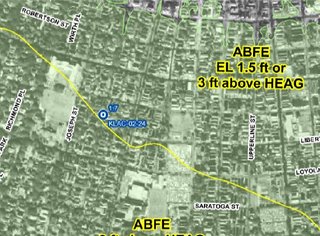
FEMA has developed Hurricane Katrina Surge Inundation and Advisory Base Flood Elevation Maps (referred to as, “Katrina Recovery Maps”) to aid Orleans Parish property owners to repair or rebuild structures to newly determined advisory coastal flood elevations. These maps are based on Flood Recovery Guidance for Orleans Parish that FEMA published in April 2006.
Holy crap! Anyone feeling like you deserve to be issued a college degree after all of this?!!
Find your map on the FEMA Web site.
Tags: Hurricane Katrina | Katrina | New Orleans | Louisiana | We Are Not OK | America's Wetland | America's Wetland | coastal restoration | Cat 5 storm protection | Levee | Flooding | Geographic Information Systems | Katrina GIS | Katrina map
posted by Schroeder @ 4:51 PM
0 comments
![]()


0 Comments:
Post a Comment
<< Home